


The Geography That Shapes Every Journey
Open Google Maps, and Colombia doesn’t look particularly large.
Compared with countries like the United States, Canada, or even Brazil, many destinations appear surprisingly close together. Bogotá to Medellín. Medellín to Cartagena. Bogotá to the Coffee Region. On the map, they seem like straightforward road trips.
But maps can be deceptive.
Digital maps are excellent at showing distances, roads, and estimated travel times. What they cannot fully capture is the geography that has shaped a country for millions of years.
That is why so many travelers are surprised when they arrive in Colombia.
A journey that appears relatively short on the map can easily become an eight- or even ten-hour drive. Sometimes, a destination only a few hundred kilometers away feels much farther than expected.
Many people assume the explanation is simply poor infrastructure.
Infrastructure certainly plays a role.
But that isn’t the whole story.
The real answer lies in Colombia’s geography.
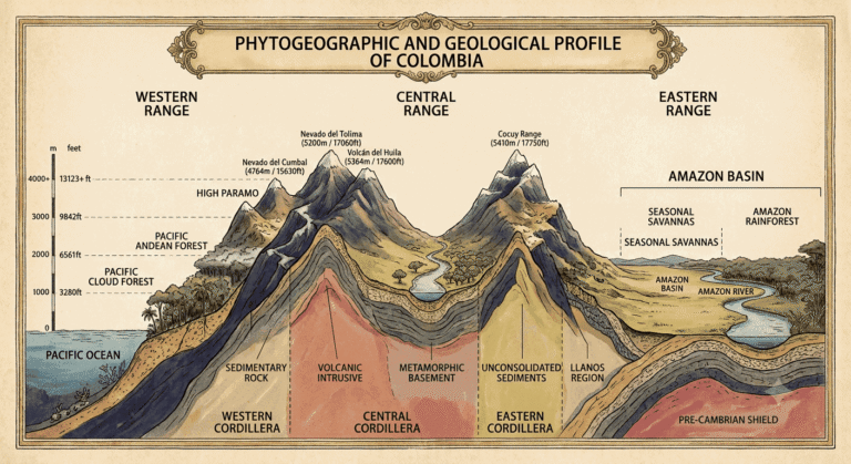
When the Andes reach Colombia, they don’t continue as a single mountain range. Instead, they split into three separate cordilleras, creating deep valleys, dramatic mountain passes, cloud forests, vast plains, tropical rainforests, and one of the most geographically diverse landscapes on Earth. For centuries, these natural barriers have shaped where people settled, how cities developed, and the way Colombians move across the country.
In Colombia, distance has never been measured only in kilometers. Elevation, terrain, and ecosystems often matter far more.
Understanding this changes the way you plan a trip.
Once you see how geography influences transportation, you’ll understand why some journeys are unforgettable road trips, why others are almost always better by air, and why Colombia’s extraordinary diversity exists in the first place.
Why Colombia Didn’t Just Build More Highways
If Colombia’s mountains make travel more difficult, a natural question follows:
Why didn’t the country simply build more highways?
The short answer is that geography has always made transportation infrastructure far more expensive and complex than a map suggests.
Unlike countries where highways can stretch for hundreds of kilometers across broad plains, Colombia’s roads must constantly adapt to the landscape. They climb steep mountain slopes, descend into deep river valleys, wind around cliffs, and cross unstable terrain. Building a highway here often requires tunnels, bridges, viaducts, retaining walls, and continuous engineering solutions that are both costly to construct and expensive to maintain.
In many ways, engineers don’t build roads through Colombia’s mountains.
They negotiate with them.
Even the most ambitious highway projects cannot ignore geography. They can reduce travel times, but they rarely eliminate the natural barriers that have shaped the country for millions of years.
Weather adds another layer of complexity.
Many of Colombia’s mountain regions receive heavy rainfall throughout the year. Landslides, flooding, and erosion regularly affect roads, particularly during the rainy seasons. In some areas, maintaining an existing highway can be almost as challenging as building a new one.
Population patterns have also influenced where infrastructure developed.
For centuries, most Colombians settled in the Andean highlands, where cooler climates, fertile soils, mining, and later coffee cultivation supported the growth of cities such as Bogotá, Medellín, Cali, and Bucaramanga. Naturally, investment focused on connecting these economic centers rather than constructing highways through sparsely populated rainforests, mountains, or remote plains.
This doesn’t mean Colombia lacks modern infrastructure.
Quite the opposite.
Over the past few decades, the country has invested heavily in major engineering projects. Long tunnels, spectacular bridges, and modern highways have dramatically improved travel between many of the country’s largest cities.
Yet even these projects illustrate the same reality: infrastructure follows the landscape it doesn’t replace it.
Beyond the main transportation corridors, geography quickly becomes the dominant factor once again.
Reaching the Amazon often means boarding a plane and then continuing by river. Visiting the Pacific coast may require both a flight and a boat. Exploring destinations such as La Guajira, the Tatacoa Desert, or remote páramos frequently involves unpaved roads where the journey itself becomes part of the experience.
Colombia didn’t simply build fewer highways than other countries.
It developed different ways of moving across one of the world’s most geographically complex landscapes.
Once you see Colombia through its geography, the country’s transportation network suddenly makes perfect sense.
Instead of measuring a journey only in kilometers, you begin to see the mountains, rivers, forests, and ecosystems that have shaped Colombia’s history and continue to shape every trip across the country today.
Geography Doesn’t Limit Colombia It Defines It
Understanding Colombia’s geography changes more than the way you travel.
It changes the way you understand the country.
Many visitors arrive expecting Colombia to function like other destinations, where highways connect every major city and travel times depend mostly on distance.
Instead, they discover a country where mountains, rivers, forests, and coastlines continue to shape everyday life.
That isn’t a flaw in Colombia’s transportation system.
It is the natural consequence of living in one of the world’s most geographically diverse countries.
The Andes concentrate much of the country’s population, while the Amazon and the Pacific rainforest remain among its least developed regions because their geography has always made large-scale infrastructure extraordinarily difficult. Along the Caribbean coast, the sea has connected communities for centuries. In the Amazon, rivers still serve as highways. Across the mountains, roads follow valleys, climb steep passes, and adapt to a landscape that was never meant to be crossed in straight lines.
Understanding this changes the way you see Colombia.
A road is no longer just a road.
A river becomes a transportation corridor.
A domestic flight becomes more than a matter of convenience.
Each reflects the geography that has shaped the country for millions of years.
Once you stop comparing Colombia to flatter countries, everything begins to make more sense.
The roads.
The flights.
The rivers.
Even the pace of travel.
They are all chapters of the same story a story written long before the first road was built.
Colombia isn’t extraordinary despite its geography.
It is extraordinary because of it.
Every mountain pass, every river, every valley, and every flight tells part of the same story. Once you understand that story, you stop seeing transportation as a challenge and begin seeing it as one of the country’s greatest experiences.
Tomás Vargas
Historian | Colombia Travel Specialist & Tour Guide | Co-Founder of Circling Colombia
Frequently Asked Questions
Why does it take so long to drive in Colombia?
Although Colombia is not a particularly large country, its geography makes road travel much slower than many visitors expect. The Andes split into three mountain ranges, forcing roads to climb steep slopes, descend into deep valleys, and follow winding routes instead of straight highways. As a result, relatively short distances can take several hours to drive.
Why does Colombia have so many different landscapes?
The country’s geography ranges from three Andean mountain ranges to Amazon rainforest, Caribbean coastline, Pacific rainforest, deserts, plains, and páramos. This extraordinary diversity is one of the reasons traveling through Colombia feels like visiting several countries in one.
Is it safe to drive in Colombia?
Driving in Colombia is possible, but it is not always the most comfortable or predictable way to travel, especially for visitors unfamiliar with local driving conditions. Traffic can be chaotic, driving standards vary, and mountain roads often involve sharp curves, heavy trucks, motorcycles and changing weather conditions. Roads can also be affected by heavy rain, landslides and occasional closures.
For travelers who are comfortable driving, scenic routes in regions such as the Coffee Region, Boyacá and Santander can be rewarding. However, for longer journeys or travelers unfamiliar with Colombia, hiring a professional driver or taking a domestic flight is often a more comfortable and efficient option. Driving at night should generally be avoided.
Are road trips in Colombia worth it?
Absolutely. Some of Colombia’s best experiences happen on the road, particularly through the Coffee Region, Boyacá, Santander, and the Andean highlands. The journey itself often becomes part of the experience.
Why are domestic flights so common in Colombia?
Because geography makes flying the fastest and most efficient way to connect regions separated by mountain ranges, dense forests, or long driving distances.
Should You Drive or Fly in Colombia?
For most travelers, flying is the best option when traveling between Colombia’s major regions. The country’s mountainous geography can turn relatively short distances into long road journeys. Driving can be worthwhile for scenic routes of three to five hours, particularly in the Coffee Region, Boyacá and Santander, where the journey itself is part of the experience. For longer distances, domestic flights are usually faster and more comfortable.
Why do short distances take so long to travel in Colombia?
Because Colombia’s geography is dominated by mountains, deep valleys and winding roads. Two cities only a few hundred kilometers apart can take many hours to connect by road because routes must climb, descend and follow the terrain rather than travel in a straight line.
How should I plan transportation for a trip to Colombia?
The best approach is usually to combine transportation methods rather than travel exclusively by road or air. Fly between distant regions, use private transportation for shorter scenic routes, and combine flights with boats when visiting remote areas such as the Amazon or Pacific coast. This allows travelers to spend more time experiencing Colombia rather than sitting in transit.